Ayodhya, a sacred city in Uttar Pradesh, is a must-visit for its temples and rich history tied to Lord Rama. A reliable Ayodhya map is your best friend to explore its spiritual and cultural gems without getting lost. Whether you’re visiting the iconic Ram Janmabhoomi Temple or the serene Sarayu River ghats, a map helps you plan your route and save time. It shows key landmarks, dharamshalas like Sri Janaki Mahal Trust, and local markets, making your trip smooth and enjoyable. Available in print at tourist centers or online through apps, an Ayodhya map highlights distances and paths, perfect for first-time visitors. This guide explains why a map is essential and how to use it to discover Ayodhya’s treasures, ensuring a stress-free pilgrimage or tour.
Why Use an Ayodhya Map
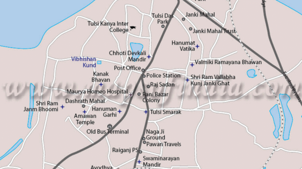
An Ayodhya map is a lifesaver for navigating the city’s narrow lanes and bustling temple areas. It pinpoints major sites like Ram Janmabhoomi, Hanuman Garhi, and Guptar Ghat, helping you plan your day efficiently. Many maps also mark dharamshalas, such as Birla Guest House, and eateries serving Awadhi food. For pilgrims, it shows temple routes and aarti timings, ensuring you don’t miss rituals. Offline maps, available at Ayodhya’s tourist offices or online apps like Google Maps, work without internet, ideal for remote areas. With a map, you can explore confidently, avoid getting lost, and make the most of your time in this holy city.
Types of Maps Available
Ayodhya maps come in various forms. Printed maps, found at railway stations or tourist kiosks, are simple and show key landmarks like Kanak Bhawan and Sarayu ghats. Online maps, like Google Maps or MapMyIndia, offer real-time navigation and traffic updates. Some apps provide temple-specific maps with aarti schedules. Local trusts, like Sri Janaki Mahal, sometimes offer free basic maps for pilgrims. Choose offline versions for areas with poor network coverage, ensuring easy navigation.
Where to Get a Map
You can grab a free Ayodhya map at the railway station or tourist information centers near Ram Janmabhoomi. Local shops sell detailed printed maps for ₹20-50. Online, download apps like Google Maps or visit Uttar Pradesh Tourism’s website for digital versions. Dharamshalas like Birla Guest House often provide basic maps at check-in. For festival times like Ram Navami, get maps early, as they’re in high demand. Always check the map’s date to ensure updated routes.
Must-Visit Places on the Map
An Ayodhya map highlights spots you can’t miss, like Ram Janmabhoomi Temple, the heart of the city’s spiritual life. Hanuman Garhi, a hilltop temple, is another key marker, offering stunning views after a short climb. Guptar Ghat, marked along the Sarayu River, is perfect for peaceful walks or boat rides. Kanak Bhawan and Sita Ki Rasoi, both near the city center, are also easy to find on most maps. These maps often show nearby dharamshalas, like Sri Janaki Mahal Trust, for convenient stays. By following the map, you can plan a route covering these sites in a day, ensuring you soak in Ayodhya’s history and devotion without hassle.
Navigating to Temples
Ayodhya maps make temple visits easy. Ram Janmabhoomi, centrally located, is a starting point, with clear paths to Hanuman Garhi (800m away) and Kanak Bhawan (1km). Most maps show shortcuts through lanes, avoiding crowded areas. Look for aarti timings on temple-specific maps to plan visits, especially for evening rituals at Hanuman Garhi. Auto-rickshaws are marked at key spots for longer distances, like to Guptar Ghat, ensuring smooth travel.
Exploring Sarayu River
The Sarayu River, a sacred lifeline, is well-marked on Ayodhya maps. Guptar Ghat, 3km from Ram Janmabhoomi, is a highlight for its serene aartis and boat rides. Maps show Ram Ki Paidi, a nearby ghat for evening prayers. Walking paths along the river are often outlined, perfect for quiet strolls. Check for boat ride points on the map, usually near Guptar Ghat, to enjoy scenic views and complete your spiritual journey.